Feeds:
Posts
Comments

Posts Tagged ‘ring of fire’

Bali Day 2: Sunday, August 6, 2017

Batur caldera panorama-s

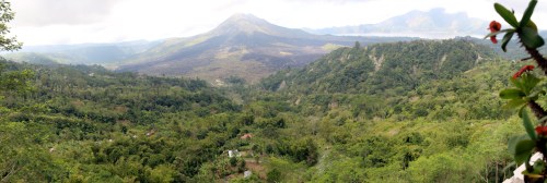
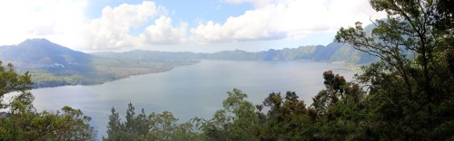
A panoramic view of the Mt. Batur caldera as seen from my restaurant in Kintamani. The darker areas of the cone are lava flows from the 2006 eruption.

We left the coffee plantation and continued our journey up the side of Mount Batur. At higher elevations, there were orange groves and stands selling oranges, small towns in valleys as we ascending the ridge lines, and ever more clouds. I tried taking photos of the oranges but the car was moving too fast to get a clear shot. Up ahead the clouds seemed to engulf the roadway, but as we reached it I saw that we had crested the edge of the caldera. We had arrived at the heart of Gunung Batur, which is the beating heart of Bali itself.

Batur details

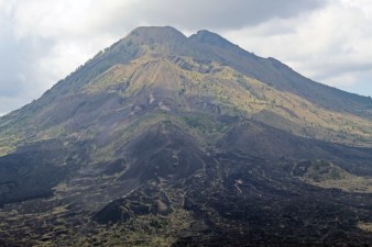
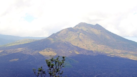
A close-up view of Mt. Batur on Bali. You can see smoke rising from fumeroles about 1/3 of the way down from the top; this is the active site of the 2006 eruptions, marked by the black lava flows that are only just beginning to be colonized by plants.

I had been afraid that I would face the same problem as at Mount Merapi three days before, especially since it had rained this morning, but luck was with me this time. The clouds were higher up than the central mountain and there were patches of sunlight shining on the peak. We drove a short distance along the edge of the crater and stopped at a white restaurant in Kintamani that hung out over the edge. Gusti said this would be where I would eat lunch. It was an Indonesian buffet. I felt guilty being the only one of us eating; Gusti and the driver were staying with the car, waiting for me to get done. I’m not used to being an exclusive guest, but I did pay 50% more for this tour because I was by myself.

Reataurant at Batur

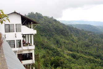
The restaurant in Kintamani where I ate lunch, hanging over the caldera’s edge. You can see the ridges in the background right that are formed by the double ring of the caldera.

I was assigned a seat overlooking the caldera and parked my camera bag while I got lunch. The buffet dishes were pretty good, but the vegan soup was the best. There were banana fritters, fried rice and fried noodles, chicken satay (on a skewer), and other dishes. I sat my food down and took photos of it with the mountain in the background. Before eating, I took advantage of the sunlight and took a series of photos of the entire caldera in a panoramic view as well as close-ups of the mountain itself. Misty clouds kept trying to blow in, and I could tell the mountain would be covered later on, but for now the view was excellent.

Gonna plug that mountain

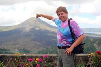
Something tells me my finger won’t be enough to plug this mountain if it decides to blow . . .

Gunung Batur is an active volcano, a composite peak growing inside a double-walled caldera. Gusti had told me that it last erupted in 2006, only 11 years ago. I could see smoke rising from fumeroles on an area about 1/3 down from the top of the peak directly in front of my position, with fresh lava flows spreading from that position down into the bottom of the caldera. The town of Kintamani was threatened and eventually moved (mostly) up to the top of the caldera rim.

3D model of Batur

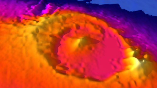
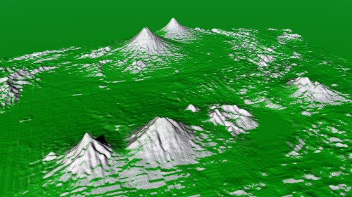
A 3D model of Mt. Batur on Bali. My restaurant was at the 7:00 position on the south rim of the caldera. You can see that it is a double ring – this mountain has blown up and collapsed at least twice, then the composite cone has formed again. The flat area to the right is the surface of the lake. This data comes from the USGS Earth Explorer website and is modeled in Daz3D Bryce.

It was hard to tell from this side, but my 3D models of the mountain show a definite double wall with the central peak growing inside both rims. The eruptions that made these walls were violent indeed, blowing the top off the mountain many years ago and collapsing the magma chamber to form the caldera that I was eating on top of. To my left I could see the double ridge of the rims. To my right was a large ridge and beyond that, a beautiful blue lake, the largest on Bali. The far wall of the caldera rose beyond the lake. Various ages of lava flows could be determined by their degree of coverage in brilliant green foliage; the 11-year-old flows were just beginning to succumb to the plants’ encroachment.

Gusti with Gunung Batur

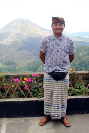
My tour guide, Gusti, at the rim of the Mt. Batur caldera. He is an excellent guide, with a great amount of knowledge about all things Bali as well as good English skills. I highly recommend looking him up for tours of Bali.

This was an incredible sight and my first good look at an Andesitic or composite volcano up close. When I took my two oldest children to Washington in 2000, we visited Mt. St. Helens but the mountain was shrouded in clouds, just at Merapi had been. I had been 0 for 2 until today. But now I’m 1 for 3, and the wait was worth it. This will be very useful for my earth science classes this year, as well as my fly-overs of Mt. Bromo and the other volcanoes.

Active volcanoes in Indonesia

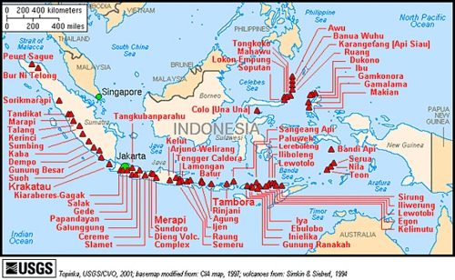
A USGS map of active volcanoes in Indonesia. Bali has both Mt. Batur and Mt. Agung, with Mt. Rinjani on a the nearby island of Lombok. There are 125 active volcanoes in Indonesia, the most of any country. They from a series of arcs where ocean crustal plates are colliding.

The Indonesian island arc of Sumatra, Java, Bali, and so on to the east sits at the edge of a very active subduction zone, where the Philippines Plate is being pushed into the Indian Plate. The Indian Plate is being pushed below, and materials eroded off the islands are caught in the subduction zone, along with water. These light materials are heated and rise to the surface as large plutons of magma, high in volatiles, that explode when they reach the surface. Repeated pyroclastic ash and andesite eruptions create the composite cones. When a magma chamber explodes and then collapses, a caldera forms. Here at Mt. Batur, one can see both, a testament to the long-term violence of Earth’s tectonic plates.

Lake Batur panorama-s

A panoramic view of Lake Batur, the crater lake inside the caldera. We drove east along the caldera’s edge until we found this overlook.

After lunch we took some photos at the wall in the parking lot, then I convinced Gusti to drive me around the rim further to get a better look at the lake and to see the mountain from a different angle. The view kept shifting as we traveled, and we found roads to take us even though we left the main highway. Gusti seemed to know every road on Bali. We stopped eventually at a pull out with a great view over the lake and back to the mountain. I took further photos, which I have pieced together into the panorama you see here. I was reluctant to leave such a view, but our next stop awaited us.

Batur from other angle 2

Gunung Batur seen from a different angle as we traversed the caldera’s rim.

Lunch with Mt. Batur

My lunch overlooking an active volcano. Some people take early morning hiking tours of the mountain and each a lunch of eggs roasted in the fumeroles of Mt. Batur.

Appease the mountain god

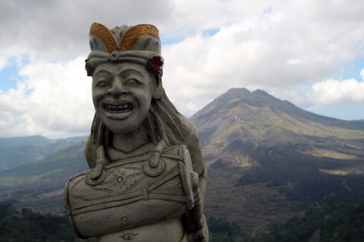
A local shrine to appease the mountain gods.

David by Lake Batur

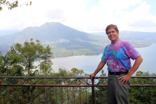
David Black overlooking Lake Batur with the composite volcano cone in the distance.

Read Full Post »

Yogyakarta Day 2: Thursday, August 3, 2017

David with jeep on Merapi

David Black on a jeep tour of Mt. Merapi near Yogyakarta, Indonesia.

After visiting Mendut Temple I was famished, so we stopped at a restaurant that had its own shrimp ponds and I ordered some honey roasted shrimp on skewers with the usual rice. It was a bit more expensive than other meals I’ve had in Indonesia, at about $15 US, but was delicious. I shouldn’t have had the smoothie to go with it, as it put me over the top on how much money I had left to spend.

Honey grilled shrimp

Honey glazed shrimp, one of the more delicious dishes I ate in Indonesia.

We traveled on toward Gunung Merapi, one of the most active and dangerous mountains in Indonesia. We gradually climbed up the mountain slope, passing through towns and smaller villages. It had been clear earlier, but clouds were beginning to gather again as the day wore on and sea breezes blew in moisture which rose up over the mountain and formed clouds. I dozed off a bit, but the rough road made sleeping difficult.

Charred furniture

Charred furniture, burnt by the pyroclastic flows of Mt. Merapi in the 2010 eruption.

After about 40 minutes of driving, we reached a series of dirt parking lots with jeeps pulling in and out. We parked and my driver took the rest of my money to pay for the ticket. I didn’t have any left for a tip for my jeep driver.

Charred motorcycles

Ruined and charred motorcycles, found under the volcanic ash after the eruption of Mt. Merapi in 2010.

I was the only one in my jeep. There is something to be said for traveling with other people, as this traveling alone can get tiresome. I wanted to share these experiences with others in the moment, not just later through these blog posts. I climbed into the back and we drove off, leaving the oiled road onto smaller trails that were barely trails at all. I tried to take some video but was knocked around so much it was impossible, so I simply tried to take photos.

Ruined bike in window

There’s not much left of this bicycle, or this house, after Gunung Merapi erupted. Artifacts from around the village have been collected for display here, a kind of impromptu museum to the eruption, which was only seven years ago.

We were heading through the jungle to a village that had been destroyed by the last eruption of Mt. Merapi in 2010. Over 350,000 people were evacuated, but the ash and fumes caused many problems with the local population and rescue workers alike. Some people either refused to leave or snuck back in before the alert was lifted, and 353 people died. The eruptions began with seismic activity in September, then pyroclastic flows and major eruptions from October to the end of November, 2010. By the start of December, the mountain quieted down again and people were allowed back to what was left of their homes.

Artifacts in ruined house

Pots, pans, and cooking stove destroyed by the 2010 eruption of Mt. Merapi in Indonesia. It felt like visiting Pompeii, but these items are only seven years old, a testament to the powerful forces that continue to shape our planet. Merapi is even more dangerous that Vesuvius in Italy.

We parked in a small lot and entered what had been a home. Artifacts of burnt out furniture, motorcycles and bicycles, and other everyday items were on display inside the charred remains of the house. It was a sobering reminder of the power of this mountain. Now it is a tourist destination.

Ruined motorcycle

Another melted and ruined motorcycle, on display at village that was destroyed by the 2010 eruption of Mt. Merapi in Indonesia.

We drove on along roads barely laid out in the volcanic ash of the eruption and parked next to a large boulder. This rock is the size of a minivan or small truck and was ejected from the volcano, traveling miles through the air to land here. I posed by it, of course. We could also look out over the lava flow itself, which issued through a small cleft in the lower reaches of the mountain.

Ruined road

Roads in the area were destroyed by the pyroclastic flows, and are now only barely passable by jeeps and motorcycles. I finally figured out to just let my body go with the bouncing, rather than trying to fight it.

Unfortunately, the mountain itself was shrouded in clouds, just as Mt. St. Helens had been when I visited there with my two oldest children in 2000. I am 0 for 2 with viewing active composite volcanoes. I’ll have one more chance with Mt. Batur in Bali.

David by alien rock

This rock was blasted out of the volcano and landed here, several miles away. From this location, one can see the main pyroclastic flow and how it is now being mined and used for concrete.

We drove higher up the mountain on a road that had been wrecked by the eruption and now was one of the roughest roads I’ve ever been on. Some sections still had asphalt on them, others were eroded and ruined, cut down to the underlying dirt and filled with huge potholes. A group of motorcyclists were having a rough go of it behind us, and I was thrown from side to side. I finally figured out it was better just to let my body go with the flow instead of trying to resist the violent motion. My hat is off to my driver for his skillful handling of the jeep.

Lava cleft

The main flow erupted through this cleft in the side of Mt. Merapi, then spread out to clog river channels and obliterate entire villages. Unfortunately, because I spent a bit too much time at Mendut Temple, the clouds had collected around Mt. Merapi itself and I wasn’t able to see it (except from the air the day before).

We came up to the end of the road at a parking lot next to the main pyroclastic flow from the eruption. Two people sought shelter in a bunker at this location as the flow came down the mountain at nearly the speed of sound. But their choice of refuge was ill advised, as the flow traveled over the top, burying the bunker underneath. They died inside. It was a bit strange that this has also been turned into a tourist destination. I took some photos of what I could see of the mountain (not much beyond the first ridge line) and the driver took photos of me by the jeep.

Plants on lava flow

The main pyroclastic flow, now turned to volcanic ash. It is already being reclaimed by plants. The main flanks of Mt. Merapi lie in the mist beyond.

Then I loaded back aboard and we traveled a short way down, then out onto the flow itself for some very dramatic photos. Then we returned to our original parking lot.

Lava flow

Another view of the lava flow from further down. We pulled the jeep over to get a better view. If the clouds hadn’t come in, the view of the mountain from here would be spectacular. Maybe some other time. This is the second andesitic volcano I’ve visited and I’m 0 for 2. The other was Mt. St. Helens.

Even though the mountain was obscured, I still enjoyed this excursion and learning about the power of this mountain and the destruction it caused only seven years ago. The area is still trying to recover, and these tourist jeep rides are helping the economy here to come back after the devastation. Already green plants are colonizing the lava flow, and soon all evidence will be erased by the jungle. That is, until next time. I don’t know if I would want to live with such a dangerous neighbor in my back yard.

Rice paddies

Rice paddies on our way down Mt. Merapi. If this mountain is so dangerous, then why do people live so close to it (even on it)? Because the volcanic ash creates very rich soil for farming, and the eruptions are infrequent enough that most people can live an entire life without experiencing one. Humans don’t have very good institutional memory.

I got back into my car and my tour guide drove me back down the mountain on the main road, a welcome relief to my jostled spine. We passed rice fields and groves growing in profusion in the rich volcanic soil. Our ride back to Yogyakarta was about 30 minutes, and he dropped me off at the hotel. It was about 4:00 and I could have gone out to explore some more, but I was very tired from such an early start, so I relaxed in my room, uploaded photos, took a nap, and watched some of the third Terminator movie and the end of Mystery Men. It had been a long but incredible day.

Rice field

Maturing rice fields and coconut palms. The soils on the slopes of this mountain are very fertile, so people continue to live here despite the danger.

Read Full Post »

Yogyakarta Day 1: Wednesday, August 2, 2017

Approaching Yogya

Approaching Yogyakarta on my flight from Jakarta: August 2, 2017

I’m sitting at Gate 16 in Terminal 3 of the Jakarta airport awaiting Garuda Flight 204 to Yogykarta, or Jogja, as people call it. I’ve been right here before, about 12 days ago, when I flew to Banjarmasin with Craig Hendrick.

Steaming cone

An active volcano in central Java, one of 125 in Indonesia that are part of the Ring of Fire.

I set my alarm for 4:30 this morning, got up and showered, got dressed and finished packing. I decided to leave my black shoes behind, as they are pretty much worn out and I haven’t really been wearing them much on this trip anyway. I spent last evening repacking, putting everything I wouldn’t need over the next five days (including all of the gifts I’ve bought) into my blue IHC bag and TGC bag and keeping my clean clothes and toiletries in the red bag. My intent is to find a storage locker at the airport, as my research says there are, and only taking my camera bag, computer bag, and red bag to Jogja.

Merapi and neighbor

Gunung Merapi (on right) and Gunung Merbabu from the air on my flight to Yogyakarta from Jakarta. Merapi last erupted in 2010, killing over 300 people.

But it didn’t work out that way. I met Nikki Moylan downstairs at 5:30, as we have arranged to share a cab to the airport. We checked out of our rooms, then ate a quick breakfast accompanied by Jennifer. The cab was waiting for us and we had a quick, non-traffic ride to the airport. I was dropped off first at Terminal 3 and got a luggage cart, went through the first security checkpoint, and checked in at the Garuda Economy Class counter. When I asked the agent where the storage lockers were, she told me that they don’t have them in this new terminal, only the old terminals. So much for research. So I had to bring all my bags with me after all and pay at the overweight baggage counter. Again.

Merapi volcanoes

Volcanoes near Yogykarta. In the foreground are Gunung Merapi (bottom left) and Gunung Merbabu. Beyond are Gunung Sumbing and Gunung Sindoro. Yogykarta lies off the image to the left, and Borobudur is in the valley between the two sets of volcanoes. This image was created using data from the USGS Earth Explorer website.

I waited at the same gate (16) that Craig and I waited at on our flight to Banjarmasin. I was writing up this post and was so intent on it that I almost missed the final boarding announcement, so I had to jump up and run through the boarding pass checkpoint at the gate. Once on the airplane I settled back and tried to find something to watch on my hour flight to Jogja.

Merapi and Merbabu

Mt. Merapi and Mt. Merbabu from GoogleEarth.

We took off over rice fields and turned toward the mountains that form the central spine of Java. As we flew along this ridge, the peaks of the volcanoes poked up through the cloud layer. Some had smoke plumes rising from their summits. There are about 125 active volcanoes in Indonesia as part of the Ring of Fire around the rim of the Pacific Ocean. The Philippines Plate is pushing into the Indo-Australian Plate, creating a subduction zone noted for its explosive volcanoes, severe earthquakes, and deadly tsunami. It is an Earth Science teacher’s dream come true to get to see this.

Central Java from air

Central Java from the air

I decided to listen to music from the selection on the in-flight screen, and started listening to the Best of Bad Company album, which rocked me all the way in to Yogyakarta. As we approached and lowed ourselves toward the city, green rice fields, streams, and trees became more obvious with beautiful clouds above and mountain peaks rearing their smoky black crowns.

Over Yogya

Approaching Yogyakarta.

We landed and I deplaned and walked across the tarmac to the Yogyakarta airport terminal, which is quite small for the number of flights it handles. It was crowded inside. I found a luggage cart and waited by the carousel until my bags came through, right after each other. There was a desk to arrange taxis into the city, so I asked them to help and a porter wheeled my bags through the crowds, through an underground walkway, to the curb where he hailed a taxi for me. We loaded up my bags and he drove me into the city to my hotel.

I am staying at the Hotel Jambuluwuk Malioboro, chosen because it has good ratings and is within walking distance (20 minutes or so) of the main shopping center, Malioboro Street. Outside the hotel is a large billboard advertising cigarettes with the required government anti-cigarette campaign on the bottom, which certainly sent mixed messages. But at least the billboard provided a good landmark to find my hotel with.

Yogya airport

The airport in Yogyakarta. It could use an expansion, because it is too small for the number of people traveling through it.

Jambuluwuk lobby

The lobby of the Hotel Jambuluwuk Malioboro, where I stayed for three nights.

I checked in and found my room on the top floor. It is a nice room with a small bathroom but nicely appointed. The carpets are a bit worn, but otherwise nice. I dropped off my bags and unpacked a few items. It requires a keycard in the slot like other hotels here to activate the lights and air conditioning, and I worked out the controls and got the room cooled down. Since it was barely noon and I was hungry, I ventured out to find at least a snack. I asked at the desk how to get to Malioboro Street – they said to go left, then left again at the first intersection and walk along that street until I crossed a river, then beyond to Malioboro. I didn’t take the first left and soon found a Alpha Mart store, where I got some Pulpy juice, a Happy Cow, and some other snacks to tide me over until I could find supper.

Yogya from hotel room

Yogyakarta from my hotel room. I had a good view of the city and could hear muezzins from several mosques at once.

It seems strange to be entirely on my own now, after having been driven and pampered for three weeks. Even with a map of the city from the front desk, I am likely to get lost. But the day was still young and I felt like exploring, so I backtracked, took the correct turn, and continued on until I crossed the river. Noon prayers were being called, so I paused and recorded some video and audio. There weren’t really any good sidewalks to cross the bridge, so I had to dodge around stalls selling red and white bunting that were in the way.

Yogya near river

Crossing a bridge from my hotel to Malioboro Street.

I stopped at a store selling batik and looked at the wares, but didn’t really like anything. I continued on another two blocks and came to Malioboro Street at last – obviously so because of the many shops, horse drawn carriages, becak drivers (pedicabs), and tourists thronging the street. I am not much of a shopper, but decided to try to get everything I needed here if possible in one afternoon and evening.

Ice Durian fruit

A stand selling iced durian fruit. The “ES” is pronounced “ice.” The smell will knock you over . . .

I smelled something unpleasant and discovered I was standing next to a cart selling durian fruit drinks. You can smell it just walking past. As I took a photo of it, a man approached me and asked if I was interested in batik. He said he knew of a place a few blocks further on that was having a batik art exposition and that this was the last day. I was interested; all the batik I saw here was simply printed, not hand drawn, and I wanted to buy some of the real thing. As we were talking, I spotted an unusual hat make of leather dyed many colors – tan, aqua, pink, and black. It actually fitted, so I had to buy it. It was about $8 U.S., or 100,000 rupiah. I put it on and wore it to keep off the hot sun. The man drew me a map, and said it was easy to find.

Atmosfear footwear

I passed this store on my way to Malioboro Street. I rather doubt this brand would catch on in America. I can’t imagine why . . .

As I walked across Malioboro Street and on down the road, a lady approached me and asked where I was going. When I told her I was going to the batik exposition, she said she lived near there and would show me the way. I was getting a bit suspicious of all this unsolicited help, but walked with her anyway. It wasn’t as if she were taking me into some small alley. I realize now that this batik workshop hires people to act as collectors of tourists, funneling them into the store to drum up more business. Pretty smart tactic, and since I wanted to see real batik anyway, it was good for me too. And there was no indication that this was the last day – it seemed to be an ongoing thing.

Little boys on bridge

Young boys in traditional clothing crossing the bridge to Malioboro Street.

I found the workshop and went inside. Since there wasn’t any big sign, it was a good thing they had these agents out scouring the streets for potential customers.

Bridge to Malioboro

Crossing the bridge from the Jambuluk Hotel to Malioboro Street. The air in Yogyakarta was much clearer than Jakarta.

Read Full Post »