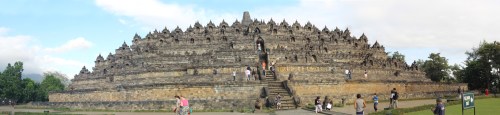
Yogyakarta Day 2: Thursday, August 3, 2017

David Black on a jeep tour of Mt. Merapi near Yogyakarta, Indonesia.
After visiting Mendut Temple I was famished, so we stopped at a restaurant that had its own shrimp ponds and I ordered some honey roasted shrimp on skewers with the usual rice. It was a bit more expensive than other meals I’ve had in Indonesia, at about $15 US, but was delicious. I shouldn’t have had the smoothie to go with it, as it put me over the top on how much money I had left to spend.

Honey glazed shrimp, one of the more delicious dishes I ate in Indonesia.
We traveled on toward Gunung Merapi, one of the most active and dangerous mountains in Indonesia. We gradually climbed up the mountain slope, passing through towns and smaller villages. It had been clear earlier, but clouds were beginning to gather again as the day wore on and sea breezes blew in moisture which rose up over the mountain and formed clouds. I dozed off a bit, but the rough road made sleeping difficult.

Charred furniture, burnt by the pyroclastic flows of Mt. Merapi in the 2010 eruption.
After about 40 minutes of driving, we reached a series of dirt parking lots with jeeps pulling in and out. We parked and my driver took the rest of my money to pay for the ticket. I didn’t have any left for a tip for my jeep driver.

Ruined and charred motorcycles, found under the volcanic ash after the eruption of Mt. Merapi in 2010.
I was the only one in my jeep. There is something to be said for traveling with other people, as this traveling alone can get tiresome. I wanted to share these experiences with others in the moment, not just later through these blog posts. I climbed into the back and we drove off, leaving the oiled road onto smaller trails that were barely trails at all. I tried to take some video but was knocked around so much it was impossible, so I simply tried to take photos.

There’s not much left of this bicycle, or this house, after Gunung Merapi erupted. Artifacts from around the village have been collected for display here, a kind of impromptu museum to the eruption, which was only seven years ago.
We were heading through the jungle to a village that had been destroyed by the last eruption of Mt. Merapi in 2010. Over 350,000 people were evacuated, but the ash and fumes caused many problems with the local population and rescue workers alike. Some people either refused to leave or snuck back in before the alert was lifted, and 353 people died. The eruptions began with seismic activity in September, then pyroclastic flows and major eruptions from October to the end of November, 2010. By the start of December, the mountain quieted down again and people were allowed back to what was left of their homes.

Pots, pans, and cooking stove destroyed by the 2010 eruption of Mt. Merapi in Indonesia. It felt like visiting Pompeii, but these items are only seven years old, a testament to the powerful forces that continue to shape our planet. Merapi is even more dangerous that Vesuvius in Italy.
We parked in a small lot and entered what had been a home. Artifacts of burnt out furniture, motorcycles and bicycles, and other everyday items were on display inside the charred remains of the house. It was a sobering reminder of the power of this mountain. Now it is a tourist destination.

Another melted and ruined motorcycle, on display at village that was destroyed by the 2010 eruption of Mt. Merapi in Indonesia.
We drove on along roads barely laid out in the volcanic ash of the eruption and parked next to a large boulder. This rock is the size of a minivan or small truck and was ejected from the volcano, traveling miles through the air to land here. I posed by it, of course. We could also look out over the lava flow itself, which issued through a small cleft in the lower reaches of the mountain.

Roads in the area were destroyed by the pyroclastic flows, and are now only barely passable by jeeps and motorcycles. I finally figured out to just let my body go with the bouncing, rather than trying to fight it.
Unfortunately, the mountain itself was shrouded in clouds, just as Mt. St. Helens had been when I visited there with my two oldest children in 2000. I am 0 for 2 with viewing active composite volcanoes. I’ll have one more chance with Mt. Batur in Bali.

This rock was blasted out of the volcano and landed here, several miles away. From this location, one can see the main pyroclastic flow and how it is now being mined and used for concrete.
We drove higher up the mountain on a road that had been wrecked by the eruption and now was one of the roughest roads I’ve ever been on. Some sections still had asphalt on them, others were eroded and ruined, cut down to the underlying dirt and filled with huge potholes. A group of motorcyclists were having a rough go of it behind us, and I was thrown from side to side. I finally figured out it was better just to let my body go with the flow instead of trying to resist the violent motion. My hat is off to my driver for his skillful handling of the jeep.

The main flow erupted through this cleft in the side of Mt. Merapi, then spread out to clog river channels and obliterate entire villages. Unfortunately, because I spent a bit too much time at Mendut Temple, the clouds had collected around Mt. Merapi itself and I wasn’t able to see it (except from the air the day before).
We came up to the end of the road at a parking lot next to the main pyroclastic flow from the eruption. Two people sought shelter in a bunker at this location as the flow came down the mountain at nearly the speed of sound. But their choice of refuge was ill advised, as the flow traveled over the top, burying the bunker underneath. They died inside. It was a bit strange that this has also been turned into a tourist destination. I took some photos of what I could see of the mountain (not much beyond the first ridge line) and the driver took photos of me by the jeep.

The main pyroclastic flow, now turned to volcanic ash. It is already being reclaimed by plants. The main flanks of Mt. Merapi lie in the mist beyond.
Then I loaded back aboard and we traveled a short way down, then out onto the flow itself for some very dramatic photos. Then we returned to our original parking lot.

Another view of the lava flow from further down. We pulled the jeep over to get a better view. If the clouds hadn’t come in, the view of the mountain from here would be spectacular. Maybe some other time. This is the second andesitic volcano I’ve visited and I’m 0 for 2. The other was Mt. St. Helens.
Even though the mountain was obscured, I still enjoyed this excursion and learning about the power of this mountain and the destruction it caused only seven years ago. The area is still trying to recover, and these tourist jeep rides are helping the economy here to come back after the devastation. Already green plants are colonizing the lava flow, and soon all evidence will be erased by the jungle. That is, until next time. I don’t know if I would want to live with such a dangerous neighbor in my back yard.

Rice paddies on our way down Mt. Merapi. If this mountain is so dangerous, then why do people live so close to it (even on it)? Because the volcanic ash creates very rich soil for farming, and the eruptions are infrequent enough that most people can live an entire life without experiencing one. Humans don’t have very good institutional memory.
I got back into my car and my tour guide drove me back down the mountain on the main road, a welcome relief to my jostled spine. We passed rice fields and groves growing in profusion in the rich volcanic soil. Our ride back to Yogyakarta was about 30 minutes, and he dropped me off at the hotel. It was about 4:00 and I could have gone out to explore some more, but I was very tired from such an early start, so I relaxed in my room, uploaded photos, took a nap, and watched some of the third Terminator movie and the end of Mystery Men. It had been a long but incredible day.

Maturing rice fields and coconut palms. The soils on the slopes of this mountain are very fertile, so people continue to live here despite the danger.