For the last week, I’ve been busy preparing for my classes at Walden School, including inventorying the science lab room (which is also my classroom) and planning out my course schedules. I’ll be teaching two sections of Chemistry, one of Astronomy, one of Computer Technology (a basic computer literacy course required in Utah), a section of Media Design, and a section of Video Production. This is, for me, a perfect schedule. In the meantime I’ve also been preparing a series of maps and 3D images of the Tintic Mining District, focusing on the ore deposits and the various mines located there. I’ve also prepared the script for this section of the video, which I have pasted below:
Tintic Geology
To understand how the ore bodies in the Tintic District were deposited, we have to start about 800 million years ago in the Precambrian Period when the western portion of the North American craton rifted away from the rest of the continent along a line where the Wasatch Front now lies – this Wasatch Line has been an important hinge line in Utah’s geology ever since. For the next 600 million years, a sequence of ocean sediments including dolomite, limestone, shale, and sandstone were deposited off the coast in the geosyncline that would become western Utah. Beginning 150 million years ago, Nevada and then western Utah were uplifted as the Farallon tectonic plate was pushed under North America. Like a throw rug being wrinkled up as it’s pushed over a hardwood floor, western Utah was folded by thrust faults into a large mountain range during the Sevier orogeny about 70 million years ago. This thrusting continued across eastern Utah and into Colorado and Wyoming during the Laramide orogeny, building up the Uintah and Rocky Mountains.
Then, about 50 million years ago, the Farallon plate began to collapse from underneath the continent. As it peeled away, a wave of volcanism moved from east to west across Colorado and Utah. Intrusive laccoliths rose to the surface, bulging up the LaSal and Henry Mountains in eastern Utah and forming explosive calderas in several places in western Utah. About 35 million years ago, a series of calderas formed in the area that would become the Tintic Mountains. A large andesitic volcano rose up from eruptions of ash and tuft.
About 31.5 million years ago, the volcano collapsed as the intrusive magma began to cool. Mineral rich fluids were injected into the surrounding limestone, quartzite, and dolomite as replacement beds. The hot magma caused the carbonate rocks to decompose; for example, limestone turns into lime or calcium oxide and carbon dioxide gas when heated. This left large cavities that then filled up with the mineral-laden magmas. These deposits are called stopes, such as the famous Oklahoma stope of the Chief Consolidated mine. The carbon dioxide released from the decomposing limestone and dolomite in turn dissolved into the hot magma, making it a kind of lava champagne, and reacting with it to form various exotic minerals, some of which are found nowhere else.
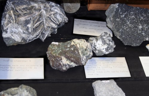
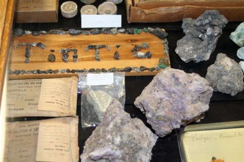
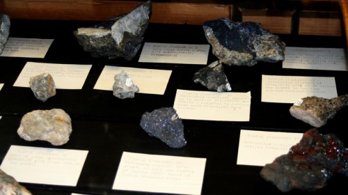
The primary ore-bearing minerals in the Tintic District are enargite, tetrahedrite, galena, sphalerite, pyrite, marcasite, and native gold, silver, and copper. But many more minerals are present, including unusual minerals that blend copper, silver, tellurium, arsenic, sulfur, carbonates, hydrodixes, etc. At the Centennial Eureka mine, over 85 different minerals have been identified, ranging from common pyrite, malachite, and azurite to minerals found only here. It is the type locality (where the mineral was first identified) for leisingite, frankhawthorneite, jensenite, juabite, utahite, and eurekadumpite. Other rare minerals include xocomecatlite, carmenite, adamite, duftite, and mcalpineite.
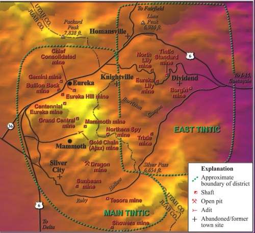
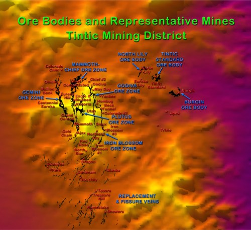
These mineral deposits occurred around the edges of the caldera and formed the five large ore zones of the main Tintic District. The Gemini Ore Zone runs to the west of Eureka south to the north edge of Mammoth Gulch. The Gemini, the Bullion Beck and Champion, the Eureka Hill, and the Centennial Eureka mines (known collectively as the Big Four) are located on this zone.
The Chief-Mammoth Ore Zone begins under the center of Eureka and extends due south across the mountain to the east end of Mammoth Gulch. The Chief Consolidated mine is located on the richest ore body, which is right under the center of Eureka city; up the hill is the Eagle and Blue Bell mine, named for the beautiful deposits of azurite found inside. Further south over the top of Eureka Peak lie the Grand Central, Mammoth, Apex, and Gold Chain mines that are also part of this deposit.
The Plutus Zone branches off of the Chief-Mammoth Zone high up in the Tintic Mountains. The Godiva Zone starts just east of Eureka and runs southeast in a curve where it joins the Iron Blossom Zone, which continues in a curve south and then southwest. Some mines in these zones include the Godiva, May Day, Humbug, Beck Tunnel, Sioux, and Iron Blossom mines.
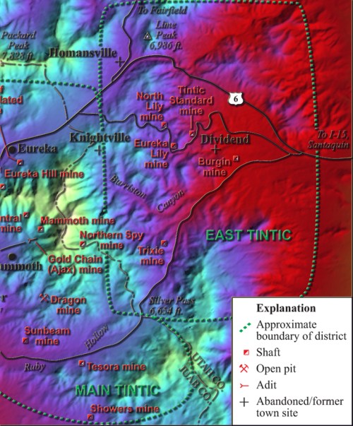
In the eastern section of the Tintic District, several zones of minerals were deposited and were among the last to be discovered because they are overlain by 400 feet of igneous rock. These bodies include the Burgin ore body, the Tintic Standard, and the North Lily bodies. Other bodies are located at the Apex and Trixie mines.
In the southern section of the Tintic District, the large replacement bodies give way to smaller fissure veins that are only two feet wide on average but can be up to 4000 feet long. Here, the mineral-bearing magma was injected into cracks and fault lines already existing in the host rocks. The Dragon mine is the only true open pit mine in the area; it sits on top of a network of fissure veins at the south end of the Iron Blossom Zone. Other mines in the area include the Swansea and Sunbeam mines at Silver City, the Tesora and Treasure Hill mines at Ruby Gulch, and the Showers mine at Diamond Gulch.
The final chapter in the area’s geomorphology began about 17 million years ago when normal faulting created the Basin and Range province, lifting up blocks to form the mountain ranges of Utah and Nevada, including the East Tintic Mountains. Other blocks sank to form the valleys, such as the Tintic Valley. Erosion has exposed the ore bodies in many places, including the outcropping that George Rust stumbled over in 1869. It was to become the Sunbeam Mine.
Great Description of the geology and mineralization of the Tintic District. I now have a much better understanding of the geomorphology and am excited to visit tomorrow. I am on my way to SLC for a tour around Tintic and Bingham before I end up in Keystone Colorado for the SEG conference.
Thanks
Dean
Hello Dean – What a delight to find your site.
My dad was a miner in the Tinctic District during world war 2. I was born at the hospital in Payson just before the war ended and was brought home to a sweet home on the main street. I think it’s still exists – from what I saw online earlier this year.
Congratulations on your position at the Walden School, which offers very fine educational opportunities. I’ll check back from time to time to see what more I can learn from your project.
Gratefully, Linda Summers (in Sedona, Arizona)
Thank you for your readable and brief overview of the Tintic. I frequently travel through the district and have just begun exploring. I have a copy of an old history of the area, and visited the museum in Eureka about a month ago.
I am interested in the various rare minerals and am hoping there are pictures available. “Eurekadumpite” sounds like someone didn’t work overtime to find an impressive name. . . .
Clark Miles
My grandfather was a miner in the Iron Blossom Mine during 1914-1915 while living in Knightsville. He got “leaded” and had to quit and return to Monroe to recuperate. My father was born in Knightsville in 1915.
William Brady
I was a miner in the Chief Consolidated mine in the early 1950’s and my father was the Superintendent until it closed in 1955. My Grandfather was also a miner and worked in the Mammoth, Grand Central, Eagle-Blue Rock and the Chief Con from 1914 to 1928. It is refreshing to see the interest in the Tintic Mining District is still alive.
I spent several years in the 1940’s and 1950’s prospecting from Diamond to Eureka.
William:
Thank you for your comment. I would love to hear any stories you might have about working in the Tintic Mines. I’m trying to put all the parts of this long-standing project together this summer and create a video about the history of the area and the current EPA superfund project there. My students are conducting a soil analysis project in and around Eureka for the American Chemical Society looking at how much contamination there is in the soil from the smelters, etc.
David Black
I wish I had more info for you. Both my father and grandfather have passed away. As you know Knightsville went ghost and nothing is left except a few foundations of the houses that were there. My grandfather left Monroe to go to Knightsville with some friends for the relatively high wages that were paid at the time (1914.) I mentioned that he was “leaded” and had to quit mining. He lost his hair and fell ill for quite a spell. For the rest of his life he had very low energy but lived until 1967.
I look forward to your publication. My father wanted to be a mining engineer after hearing the stories from his father and visiting various sites but the Depression killed that dreamI
I do remember my father telling me a story of a cousin or uncle that supposedly backed an early dump truck over the end of a load out & jumped as the truck plummeted downgrade. He was unhurt.
Great article, very informative and interesting read! I was wondering if it would be possible to find out the references you used? I’m an avid geologist but have found it difficult to find much in-depth literature on the Tintic District.
Kind regards,
Matt.
Here is some good information I found about the Tintic area:
Click to access report.pdf
Click to access report.pdf
Excellent papers! Thank you for sharing them!
-David Black
Excellent papers on the Tintic Mining District. Thank you for sharing them!
Those ugly rocks ruined Eureka. That project was a waste of public money.
Will you get ahold of me? I am deeply interested in this area for geologic and environmental reasons. Email me or call me at 801-661-6928. I am interested in soil restoration, history preservation, botanical research, mining and geology research. My end goal is to develop environmentally friendly small scale mining and homesteading in a way that makes this areas and others resources for available to an average person. I would to create a botanical based clean up of this district so it can preserve the beauty and legacy of the history of this area and increase the value of this by way of making it environmentally safer and more beautiful. I feel this is a benefit to all. I am willing, as a student of this idea, and a lover of this land to offer my labor and time and energy for free. The cruel treatment of this land by the EPA is not only ugly and devaluing to this land but the rip rap will never allow a more natural reclaimation and beautification of this land. I grew up here and still live close by. My number is 801-661-6928
Hi thanks for posting thhis
My great grandfather worked in the May Day Mine in Eureka, Utah and according to a newspaper article was killed in an accident in the mine in July of 1915. I can’t find any information on an accident in the mine around that time. If anyone has any knowledge of such an incident I would greatly appreciate how to obtain it.
Thank you.