Mine near Silverton, Coloado
My exploration of the Mayflower Mill took quite a bit of time, but it was worth detouring back to Silverton just to see it. I was quite hungry by the time I finished, but I stopped at some interpretive signs along the road back to town, including a road map of the area showing the roads over Cinnamon and Engineer Passes to Lake City. I would like to explore these routes, but knew my minivan was no match for those passes. I’ll take the long way round.

History of mining around Silverton, Colorado.
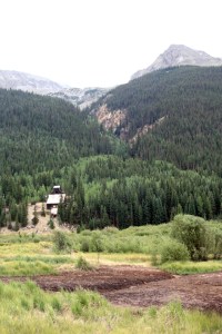
Closer to Silverton was a display on the tailings from the Mayflower Mill and a description of the Silver Lake Mill across the valley, as well as the mansion called Waldheim that was built by Edward and Lena Stoiber, who also built the mill. It was eventually sold to the Guggenheims and demolished for salvage in the 1940s.
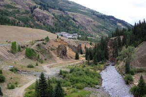
Mayflower Mill and tailings pile. The Silver Lake Mill was across the Animas River from the Mayflower.
Back in Silverton, I found a promising place to eat and had a tasty lunch of buffalo chicken wings at Handlebar’s Restaurant and Saloon. Certainly much better than the place I ate at on Tuesday. The train crowd was leaving by the time I finished and the town was more relaxed.

Main Street in Silverton, Colorado.
I had one more attraction to see on my Silverton Heritage Pass, and that was the San Juan County Historical Society Mining Heritage Center housed in the old Silverton jail. Downstairs was an excellent exhibit of local minerals, and the jail itself was interesting. From the jail, you pass through a tunnel and connect with another building to see the Heritage Museum. It had good displays of mining equipment and how it was used, including engineer’s transits, safety equipment, and general artifacts from the town itself.
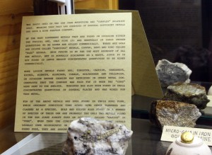
Gold ore from the San Juan Mountains on display in the San Juan County Historical Society Mining Heritage Center in Silverton.
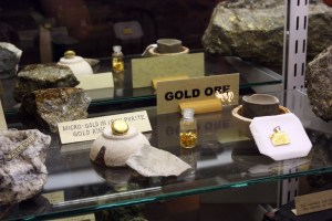
More gold ore in the Silverton museum.
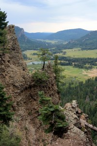
Silverton got its start after the Brunot Treaty of 1873 opened the area to settlement and pushed the Ute Indians out. Almost immediately mining began in the area and continued until 1991 when the last mine shut down. At its height in the 1880s, Silverton’s population reached 3000, with many coming from European countries. The mines advertized in foreign newspapers and promised land and wealth. Usually the younger male members of families came first, hoping to save enough money to send for the rest of their families.
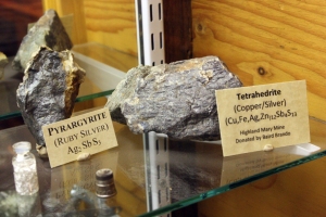
Silver ore from the San Juan Mtns., on display in the Silverton museum.
Silverton was a rough town, with gambling, saloons, and other forms of recreation that led to the need for a good jail. Built in 1902, the jail was rarely empty. The jailer’s family lived on the main floor and the cells were on the top floors, with storage in the basement. Eventually, as mining dwindled and the population decreased, the jail was shut down and used to store artifacts for a proposed museum, which finally opened in 1965. Now, a large addition has become the Mining Heritage Center.
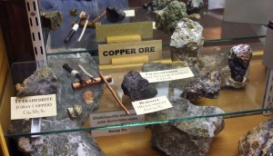
Copper ore on display in the Silverton museum.
After completing my tour, I drove out of town on Highway 550 and crossed over Molas Pass again, returning to Durango for the third time in five days. I did stop at the train station one last time, but they still had not seen my hat. Oh well! I drove on out of town on Highway 160 toward Pagosa Springs.
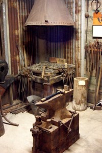
Typical mine blacksmith shop, recreated in the Silverton museum.
It was a pleasant drive, threatening rain but never more than a light drizzle. It’s about 60 miles from Durango around to Pagosa Springs, which surprised me for being such a large town. I didn’t stop to explore, as I was already behind schedule to get to my camp for the night. It must have a fairly large airport judging from the midsized jet I saw taking off.
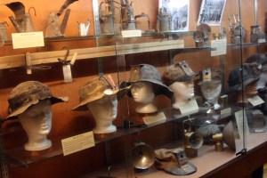
Progression of miner’s hats and lamps.
Highway 160 continued on to Wolf Creek Pass. I stopped at a scenic pullout along the switchbacks leading up to the pass and could see a long way down a glacial valley to the west. This is the site of one of the old songs by C. W. McCall, called “Wolf Creek Pass.” The song follows the misadventures of truck driver Earl and his companion, whose 1948 Peterbilt 18-wheeler goes out of control driving down Wolf Creek Pass, until they crash into a feed store in Pagosa Springs, losing most of their cargo of chickens along the way.

Miner’s carbide lamp and cross-section diagram.
I looked at Earl and his eyes was wide
His lip was curled, and his leg was fried.
And his hand was froze to the wheel like a tongue to a sled in the middle of a blizzard.
I says, “Earl, I’m not the type to complain
But the time has come for me to explain
That if you don’t apply some brake real soon, they’re gonna have to pick us up with a stick and a spoon…”
(“Wolf Creek Pass” written by Bill Fries and Chip Davis, sung by C.W. McCall)
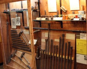
Drill steals, including single and double jacks and Leyner drill bits.
Interestingly enough, another song by C. W. McCall is entitled “Black Bear Road” and talks of the legendary jeep route between Telluride and Ouray. Since I started out in Ouray this morning, I’ve definitely been in C. W. McCall country.
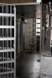
Jail cell in the old Silverton, Colorado jail.
But the funny thing is, C. W. McCall never existed. It was a pseudonym of songwriter Bill Fries who, along with Chip Davis, worked for an advertising company in Omaha. They were hired to do a marketing campaign for the Metz Baking Company, which made Old Home Bread. They came up with a trucker named C. W. McCall who delivered Old Home Bread to the Old Home Filler-Up and Keep On a Truckin’ Café, where he meets with waitress Mavis Davis. The commercials were a big hit and won the Clio Award. Bill and Chip decided to take the C. W. McCall persona on the road, and released several “outlaw country” albums. In 1976 they ignited the citizen band radio craze with the song “Convoy,” which earned them a gold record.
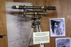
Mine engineer’s surveying transit.
While on the road, Chip began experimenting with a fusion of medieval music with modern instruments and synthesizers and created the group called Mannheim Steamroller. The first album was rejected by all the major record labels, so Chip set up his own record label called American Gramaphone. Their Fresh Aire albums, especially the Christmas albums, are still among my favorite.
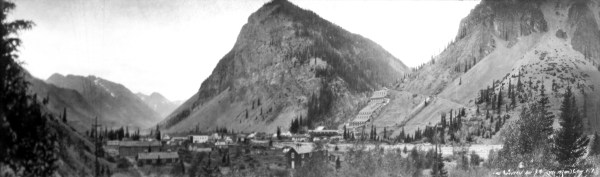
1930s photo of Silverton, Colorado with a large mill complex in the background.
Bill Fries eventually moved to Ouray, Colorado and was elected mayor there in 1986.
View from Wolf Creek Pass toward Pagosa Springs.
It was raining a bit more heavily as I crossed over Wolf Creek Pass but lightened up as I headed down into South Fork. I had a reservation at a large RV park a short distance up Highway 149. I had set up the reservation long before I had the trouble with my tire and had to modify my itinerary; originally, I was going to come in from the north on Highway 149. Fortunately, even though I was late, the manager was still in the office making bread for a bake sale in the commons room. My camping spot was right next to this room and the spot was so narrow my tent was literally wedged between the building and my neighbor’s pop-up tent. I covered my tent with a tarp in case of rain and to keep out the bright light on the side of the building. I ate supper, got my electronics charged up, uploaded my photos, and slept well despite the light.
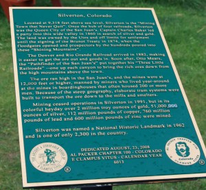
Sign near the Silverto museum detailing the history of the area.


